 |
| Source: National Library of Scotland Bartholomew Survey Atlas of Scotland, 1912 |
Showing posts with label Maps. Show all posts
Showing posts with label Maps. Show all posts
Sunday, July 26, 2020
Friday, July 3, 2020
Cameron Residing At Arnisdale Of Glenelg
At Lochiel's proof, held at Banavie, on 11th May, 1825, Glengarry was much in evidence, and at the outset succeeded, at least for the time, in having the proposed evidence of Alexander Cameron, Esq.,
 |
| Source (Glenelg in Scotland) |
residing at Arnisdale of Glenelg, rejected. Mr. Cameron was on the point of starting for America animo remanendi, and the time was scrimp. Being only sixty-five years of age, Glengarry argued
that the Commission only covered aged witnesses (above seventy), or such as from ill-health and infirmity might at any moment die. [Source]
Thursday, April 9, 2020
Donald Cameron, Tenant Of Kinlochiel
Donald Cameron, tenant of Kinlochiel, was then adduced, aged seventy-five, and showed minute knowledge of Glenkingie and its sheilings from 1775 downwards.
 |
| Source Glen Kingie, Highland, Scotland |
He also spoke of the festivities consequent on the restoration of the Lochiel Estates, in 1785, in these terms — There was great rejoicing in the country, and plenty of bonfires and drinking. Perhaps the most interesting part falling under Cameron's examination occurred when Lochiel's Agent put the following question : —
Whether it consists with the knowledge of the witness that, from the year 1775 down to 1820, the tenants of the farms on the north side of Loch Arkaig, and of Shanvall and Glackfearn in Glendessary, had the quiet and peaceable possession of their respective farms and sheilings, as above enumerated, and as parts and portions of the estate of Lochiel, and without any molestation whatever, either during the time that the estate was under the management of His Majesty's Commissioners or
since. [Source]
Sunday, January 12, 2020
Renumbering From Lancaster To Lochiel
(From a group e-mail):
With renumbering, Concession 10 Lancaster would likely have become Concession 1 Lochiel.
Lots 27, 28 Concession 1 Lochiel would not have been particularly close to lots A Concession 3, and 4. You can see these lots on the county atlas page - Glengarry Lochiel.
Monday, December 16, 2019

Tuesday, October 15, 2019
Cameron Deed# D-2347 In Sombra Township

Sombra Township, Lambton, Ontario, Canada
Deed# D-2347
Made: 2 December 1868
Registered: 29 May 1869
...conveyances between Duncan Cameron of the Township of Moore in the County of Lambton in the Province of Ontario Late Province of Canada, Yeoman, of the first part
Ellen Cameron of the same place wife of the said party of the first part of the second part
And
David Wilson, Yeoman, of the Township of Sombra....
 |
| Partial Map - Lambton County - McGill University |
....being in the village of Wilkesport, Township of Sombra, in the County of Lambton
in the Western part of the said province of Ontario
1/5 acre
Lot#3, Block F...part of the North 1/2 Lot 16, Twelfth Concession
fronting on the north side of Queen Street in the said
Village of Wilkesport
Witness: Alexander MacDonald
Cross-posted at In Deeds
Monday, September 23, 2019
Alexander Cameron And The Greenville Tracts
 |
| Ca 1773 "Parker" Map - South Carolina And Cherokee Lands (LOC) |
"...a series of individuals attempted to secure tracts of Greenville land while it was still beyond the [Native American] boundary. The first of these individuals was none other than Alexander Cameron, the deputy Indian superintendent...".
 |
| Fort Prince George On A 1794 South Carolina Map (LOC) |
"A Scot...[with] a commission as an ensign with the British Army, stationed at Fort Prince George (1762-1763). He settled on a land grant at Long Canes Creek in 1763...".
"He fathered a child by a Cherokee woman...chiefs offered him a tract of Greenville land in February 1768...". In 1770 the Cameron land was identified by surveyor Patrick Calhoun as 'Land reserved for an Indian Boy begotten by a White Man Alexander Cameron.'"[Source of all of the above text]
Cross-posted at Detour Through History
Saturday, February 23, 2019
Alexander Cameron At Fort Prince George
 |
| A Map of the lands ceded by the Cherokee Indians to the State of South-Carolina... (LOC) |
"Stuart, who likely had observed [Alexander] Cameron serving at Fort Prince George during the Cherokee War of 1759-1761...". [Source]
Tuesday, February 12, 2019
Muirsherlich and the Inveruiskavouline (Kilmallie) Camerons
 |
| Partial View Of 1805 Map Of Scotland (Source - LOC) |
Google Maps shows Muirsherlich just north of Fort William.
"The upper bank of the canal between Loy aqueduct and the high ground of Strone has been formed with earth removed from the latter place and the lower or southern bank is to be formed in like manner. This is now in operation by means of a railway and waggons."
The other ridge of ground half a mile beyond the Muirshearlich aqueduct furnishes earth for the banks of the canal between that place and Strone and this operation which will cause a sufficient depth of excavation at Muirshearlich may be expected to be complete at the end of the present year. [Source]
Note: It's been stated that the Muirshearlich and the Inveruiskavouline (Kilmallie) Camerons have the same Cameron ancestors.
Wednesday, March 28, 2018
William Cameron Of Waupaca
Genesee County, Michigan
Deed# 30-515
17 August 1857
William _ Cameron of Waupaca, Waupaca, Wisconsin
To
Allen P. Cameron of Detroit, Wayne
S 1/2 of NW 1/4 of Section 34 Twp 8 North of Range 8 East, Genesee County
Witnesses: Milton A. Hamilton; Garry Spencer
Notarized in Wayne County
Waupacca, Waupaca, Wisconsin, United States
Wm Cameron M 35 Canada
Judith A Cameron F 30 Canada
Eveline Cameron F 13 Canada
Mariah Cameron F 11 Canada
Florence Cameron F 1 Wisconsin
Tuesday, January 9, 2018
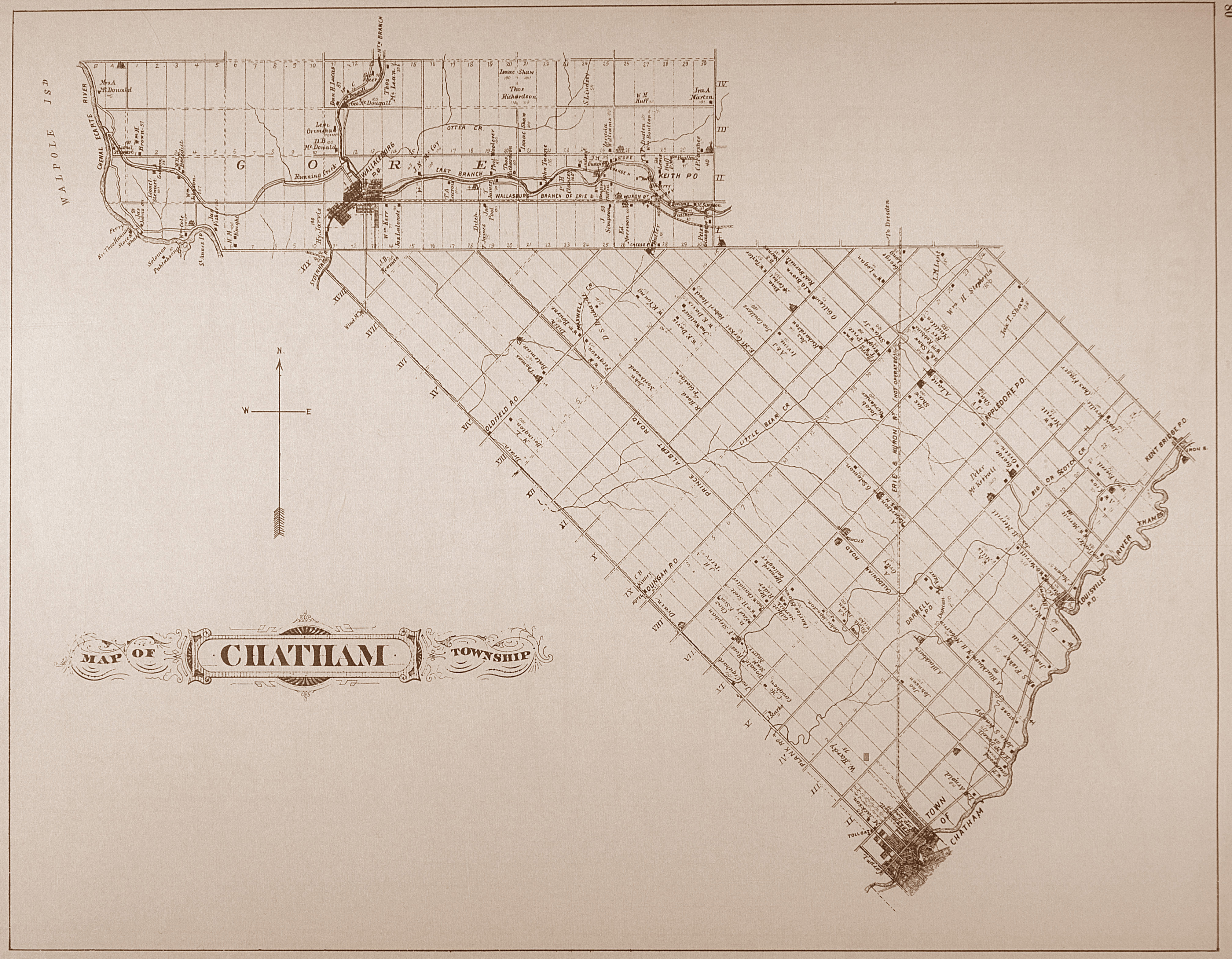
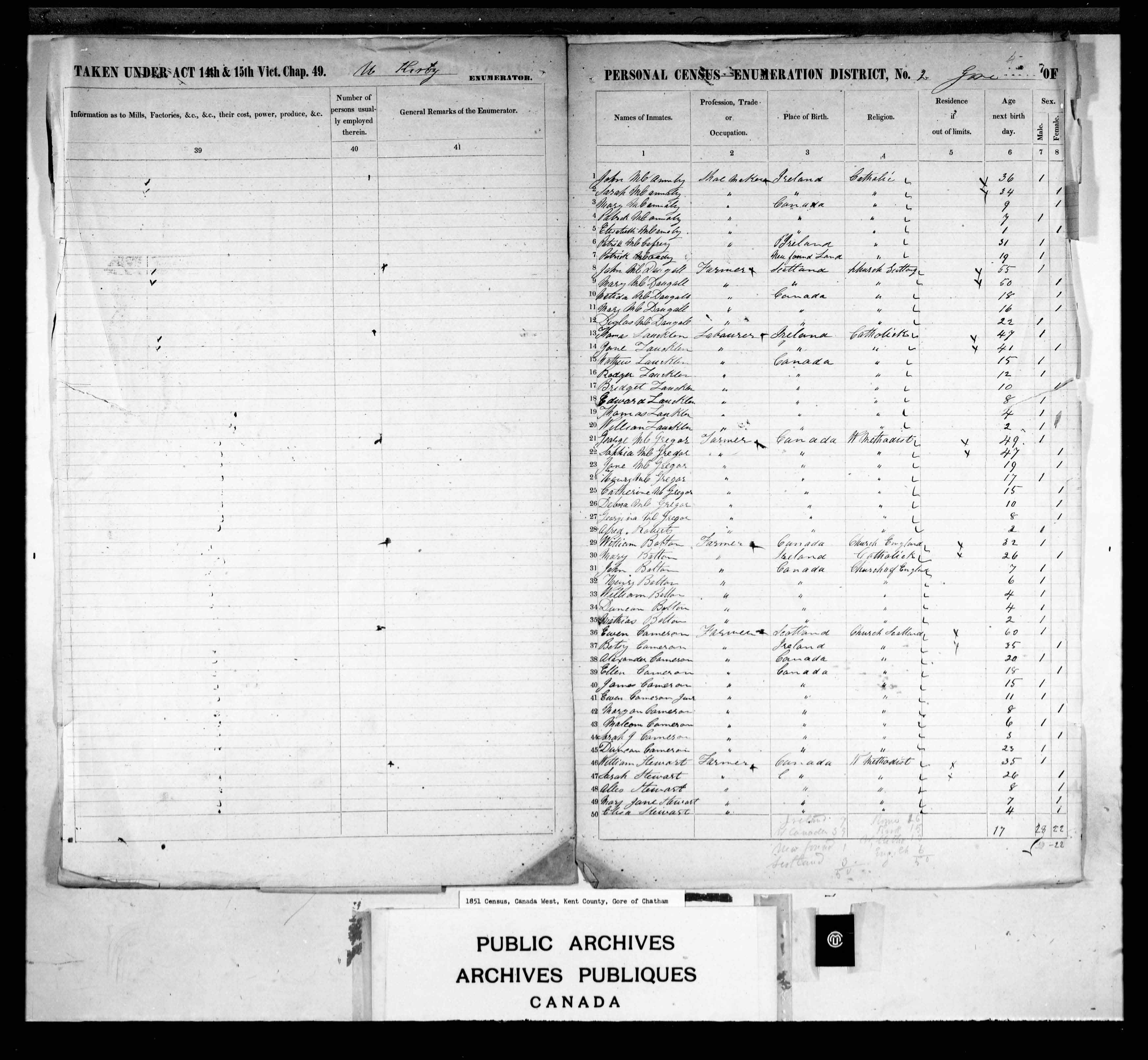
Ewen Cameron And 1851 Census

Concession 2 Lot 16
Gore of Chatham
Kent County
Ontario, Canada
| Source - McGill Library Map Kent County, Ontario, Canada Gore of Chatham |
Age 60 (next birthday)
Born in Scotland
Member Of The Church of Scotland
Wednesday, November 15, 2017
Abaco In The Bahamas
| Source |
An excerpt from the Pannebecker message board at Rootsweb:
"Thomas Brown was not only enterprising, he was well placed with both the outgoing and incoming governors. Brown was initially awarded two hundred acres on Abaco in the Bahamas...". He would do better than that. Before his Rangers left Florida, some of them had decided to live as Brown's neighbors on Abaco."
"Near him [Captain Smith, on land called Spencer's Bight] were Captain Alexander C. Wylly, author of "The Sketch of the Siege of Savannah," Captain Donald Cameron...Conrad Pennybaker...".
| Source |
Sunday, November 12, 2017
Cameron Disclosed His Plans
 |
| Map Of Cherokee Nation |
A civil war was brewing, British Agent Alexander Cameron explained to the incredulous Cherokee.
| Source |
Thursday, August 31, 2017
Friday, April 14, 2017
Moving Through Canada
Lots of gaps left to fill.....
Allan Cameron of Finch and Ann McMillan of Lancaster were married 24 March 1808 (both were born in Scotland).
In 1852 they lived in Templeton, Quebec, Canada:
 |
| LOC Map |
The family was living in Buckingham, Quebec, Canada, in 1861; in 1871 they were in L'Ange Gardien, Quebec.
Wednesday, April 12, 2017
John And Mary Of Glen Nevis
Except from Oldest Loyalists... (John and Mary Cameron)
John Cameron, died at 99 (ON)
A now-neglected tombstone proclaims the long lives of United Empire Loyalist John Cameron and his wife Mary (nee Cameron).
John Cameron (1725 - 1824), Clunes UEL
died May 10, 1824 – aged 99 years
Mary Cameron
died Nov 3, 1830 – aged 91 years
She was of Glen Nevis
John and Mary Cameron had left their home near Fort William, Scotland for New York State aboard the "Pearl" on 18th October 1773... .
At the onset of the revolution he and his oldest son, Alexander, joined the King's Royal Regiment of New York... .
...he was awarded with the West Half of Lot 6 in the 4th Concession of Cornwall Township, as is seen on the *1786 McNiff map. It is on a corner of this Lot that his tombstone still stands.
— Submitted by Catherine Whiteley
*4TH CONCESSION, ON EASTERN BOUNDARY.
6, Alex. Cameron, John Cameron
[Source]
Thursday, January 12, 2017
Allan Cameron And The Farm At Callart
Note: See Link For Placement On A Map
Plan Of The Farm At Callart, Kilmallie, Inverness-shire
The National Records of Scotland
Date 1773
Plan of vein of slate through the forfeited estate of Callart. Outcrop of limestone, Callart House and ferry house noted. Extension of vein at Ballachulish, Lismore and Appin parish, Argyll, shown.
Exchequer Records: Forfeited Estates Papers 1745: Particular Management: Allan Cameron of Callart, Callart Estate (E743)
Thursday, December 8, 2016
Cameron's Followers
Military Maps of Scotland (18th century):

Title: A description of the Highlands...several clans...ye forts...roads
Name: Lempriere, Clement
Date on Map: 1731
All images © National Library of Scotland
There are other Cameron notations on the map.
Thursday, March 6, 2014
The John Cameron Property
Found in Hyrdoone...
An archaeological assessment....from the Hawthorne Transformer Station (Ottawa) to the Cumberland Junction.... .
"One designated heritage building is partially within the corridor. This is the Cameron Home on
Queen Street just west of Cumberland. John Cameron settled on this property in 1851 and built the stone house sometime between then and 1861. Outbuildings associated with this farm extend into the hydro corridor."
There's also plat maps.
Friday, October 25, 2013
Alexander Cameron's SC Acres
Cross-posted at In Deeds.
Posted online at the South Carolina Archives:

S213184: Colonial Plat Books (Copy Series)
Subscribe to:
Posts (Atom)

